

What Does the Circled “1” Mean on Google Maps? Here’s the Answer
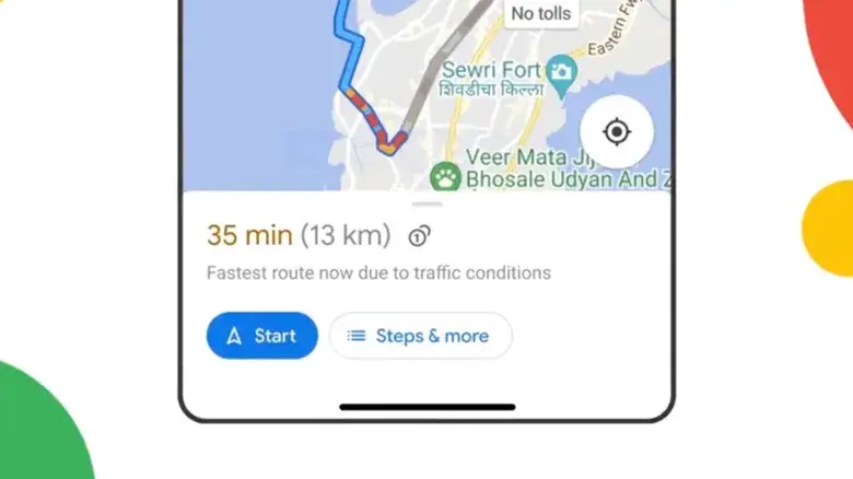
If you regularly use Google Maps for driving directions, you may have noticed a small “1” inside a circle appearing next to a route. At first glance, it can look like a road number, route marker or navigation warning.
However, the symbol has a much simpler meaning: it indicates that the route includes a toll road or toll charge.
Google Maps uses this icon to help drivers identify routes where they may need to pay a fee during their journey.
What Does the Circled 1 Icon Mean?
The circled “1” icon is associated with toll charges on Google Maps.
When you search for driving directions, Google Maps may display the icon alongside the estimated travel time and distance. If the route includes a toll, the app can also show an estimated amount that you may have to pay.
The actual price can vary depending on the route, toll authority and whether you have selected the option to view toll-pass pricing.
So, if you see something like:
🚗 35 min → 🪙 1 → $5
the symbol is indicating a toll-related cost rather than the number of toll gates or a road number.
Why Does Google Maps Show Toll Prices?
Google Maps introduced toll-price information to make route planning easier for drivers.
Before choosing a route, users can compare the expected travel time with potential toll costs. This can help determine whether paying for a faster route is worthwhile or whether a toll-free alternative makes more sense.
For example, Google Maps might provide two options:
- Route A: 30 minutes with a toll
- Route B: 36 minutes with no toll
You can then decide whether saving six minutes is worth paying the toll.
How to See Toll Prices in Google Maps
Google Maps provides an option for displaying estimated toll-pass prices where the feature is supported.
To check the setting:
- Open Google Maps.
- Tap your profile picture.
- Open Settings.
- Select Navigation.
- Go to Route options.
- Look for See toll pass prices.
- Turn the option on.
The availability of toll-price information can vary by location, and estimates may not always reflect recent changes made by toll-road authorities.
How to Avoid Toll Roads in Google Maps
If you don't want to pay toll charges, Google Maps also allows you to request routes that avoid toll roads.
On your phone:
- Open Google Maps.
- Enter your destination.
- Tap Directions.
- Select the driving option.
- Open the route options.
- Enable Avoid tolls.
Google Maps will then attempt to find a suitable route without toll roads.
However, avoiding tolls may sometimes result in a longer journey. In some locations, avoiding every toll road may also be impossible depending on the available roads.
Does the Circled 1 Mean One Toll Gate?
No.
The number inside the circle should not be interpreted as the number of toll booths or toll gates on the route.
Instead, it is part of Google Maps' visual indicator for toll-related route information. The amount displayed near the icon provides information about the estimated toll cost when available.
Are Google Maps Toll Prices Always Accurate?
Google Maps provides estimated toll prices rather than guaranteeing the exact amount you will pay.
Google gathers toll information from road authorities and other sources. If a toll authority recently changes its prices, there can be a delay before the updated information appears in Google Maps.
For this reason, drivers should treat the displayed amount as an estimate and check the relevant toll authority when an exact fee is important.
What If You Don't See the Toll Icon?
Not every route will display the circled “1” symbol.
You may not see it when:
- The route does not include a toll road.
- Toll information isn't available for that location.
- Your Google Maps version needs updating.
- The toll road's pricing information hasn't been integrated.
- Regional availability differs.
Google also notes that navigation and certain information features are not available in every country, region or language.
Google Maps Offers More Than Basic Navigation
The toll indicator is just one of many pieces of information Google Maps can provide while planning a trip.
The app can show alternative routes, traffic conditions, public transportation options and other useful information. Google says Maps uses real-time traffic information to help find suitable routes and can provide alerts about traffic and road conditions during navigation.
Understanding these symbols can make Google Maps easier to use, especially when you're driving somewhere unfamiliar.
Final Thoughts
The next time you see a “1” inside a circle on Google Maps, you don't need to worry about it being a warning or a road number.
The symbol indicates that the selected driving route involves a toll, with Google Maps potentially showing an estimated toll cost alongside the route.
If you want to save money, you can compare the available routes or enable Avoid tolls before starting your journey. If saving time is more important, you can choose the toll route and pay the applicable fee.
Understanding small Google Maps icons like this can make trip planning easier and help you avoid unexpected road charges.
Leave a comment
Your email address will not be published. Required fields are marked *